Understanding GPR Utility Surveys PAS128
In the dynamic world of construction and infrastructure development, the need for precise mapping of underground utilities has never been more critical. Ground Penetrating Radar (GPR) utility surveys are emerging as a vital tool for professionals in London, Surrey, Sussex, and beyond. These surveys not only assist in identifying the location and depth of buried services but also ensure that projects comply with the stringent standards set by the Publicly Available Specification 128 (PAS128). When exploring options, GPR Utility Surveys PAS128 Kent provides comprehensive insights into how this technology can facilitate safer and more efficient excavation practices.
What are GPR Utility Surveys?
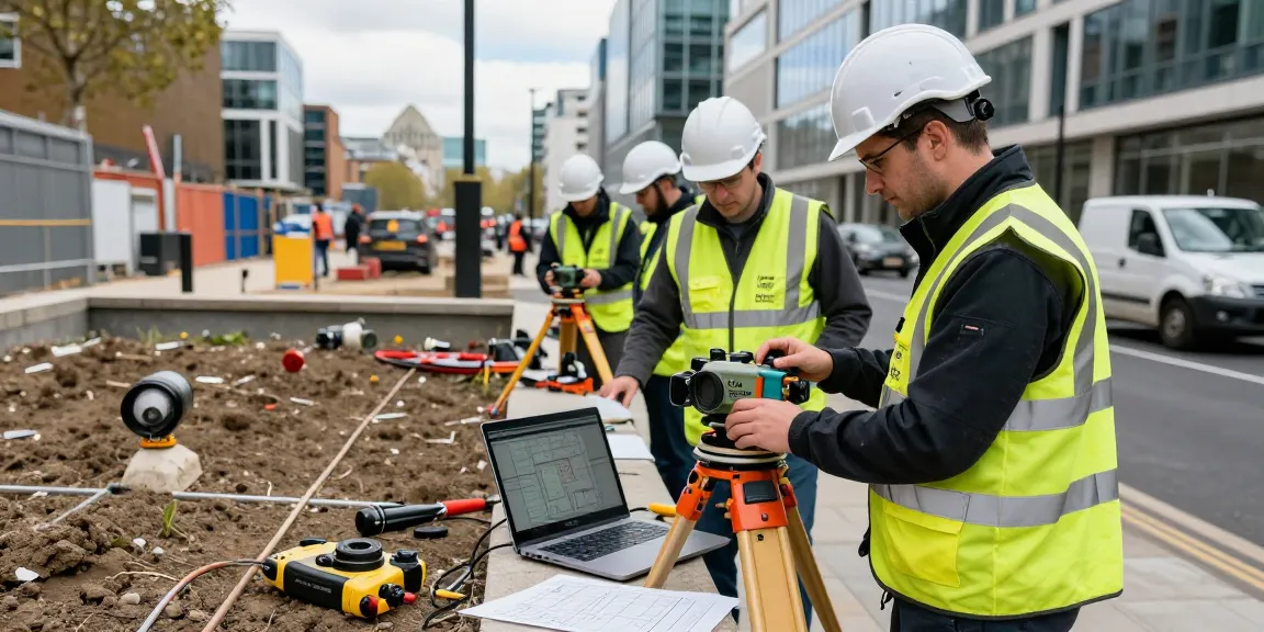
GPR utility surveys are geophysical investigations that utilize radar pulses to identify, map, and assess the condition of subsurface structures. This technology is extensively used across various sectors, including construction, civil engineering, and environmental studies. By penetrating the ground, GPR can retrieve high-resolution images of underground utilities such as water pipes, electrical cables, gas lines, and telecommunications systems. The primary goal of these surveys is to prevent accidental damage during excavation, which could lead to service interruptions or safety hazards.
The Importance of PAS128 Standards
The PAS128 framework is pivotal for utility mapping and survey accuracy. Established by the British Standards Institution, PAS128 outlines the procedures and methodologies necessary to identify and report on underground utilities safely. The specification categorizes surveys into different levels (A, B, C, D), each denoting the level of information provided, from rudimentary mapping to comprehensive verification of utility locations, depths, and conditions. Adhering to PAS128 standards not only mitigates risks but also reinforces compliance with legal and regulatory obligations, ensuring that projects are executed safely and efficiently.
How GPR Technology Works
The operation of GPR technology is based on the reflection of electromagnetic waves. The GPR system emits high-frequency radio waves into the ground, which then interact with various subsurface materials. When these waves encounter different objects or interfaces, they reflect back to the surface, where they are captured by the system’s antennas. This data is processed to create detailed images that reveal the location and characteristics of underground utilities. GPR is particularly effective in a range of materials, including soil, concrete, and rock, making it a versatile tool for various surveying applications.
Benefits of GPR Utility Surveys PAS128
Minimising Risk in Excavation Projects
One of the most significant benefits of conducting GPR utility surveys is the substantial reduction in risk associated with excavation work. By accurately identifying the location of buried utilities, construction teams can avoid damaging critical infrastructure, which can lead to dangerous situations and costly repairs. The data obtained from GPR surveys allows for proactive planning, minimizing the likelihood of utility strikes and ensuring that projects proceed smoothly.
Cost Efficiency and Time Savings
While some may view utility surveying as an additional expense, it often results in significant cost savings over the long term. By preventing accidental damage to utilities, GPR surveys help avoid costly delays, emergency repairs, and potential legal ramifications. Furthermore, the insights gained from these surveys enable more efficient project planning and execution, allowing teams to allocate resources more effectively and adhere to timelines.
Ensuring Compliance with Regulations
Complying with local regulations and safety standards is crucial for any construction project. GPR utility surveys that adhere to PAS128 guidelines help ensure that all necessary precautions are taken to identify and manage underground utilities. This compliance not only promotes safety but also enhances the reputation of contractors by demonstrating a commitment to industry standards and best practices.
Steps Involved in Conducting GPR Utility Surveys
Pre-Survey Desktop Studies
The process of conducting a GPR utility survey begins long before any fieldwork is done. Pre-survey desktop studies involve reviewing existing documentation, such as utility maps, historical records, and previous survey data. This preliminary research helps surveyors identify potential utility locations and inform their strategies for on-site investigations.
Site Reconnaissance Techniques
Following the desktop study, surveyors perform a site reconnaissance visit. During this phase, they visually inspect the site for accessible surface utilities, manholes, and other markers that may indicate underground services. This step is crucial as it helps surveyors develop a deeper understanding of the site context, allowing for better planning and execution of the GPR survey.
Data Collection and Analysis
Once the preparatory steps are complete, data collection can commence. Using advanced GPR equipment, surveyors conduct systematic scans of the designated area. The collected data is then processed through specialised software to create detailed images of the subsurface conditions. Data analysis involves interpreting these images to identify and map out underground utilities accurately. Final reports are compiled, detailing the findings and providing clients with actionable insights.
Common Challenges in Utility Surveys and Solutions
Dealing with Site-Specific Conditions
Utility surveys can be fraught with challenges, particularly when site-specific conditions complicate GPR data collection. Factors such as soil type, moisture content, and existing structures can affect the quality of the data obtained. To address these issues, surveyors must be adaptable, employing various survey techniques and technologies, such as electromagnetic induction, to complement GPR findings.
Overcoming Equipment Limitations
While GPR is a powerful tool, it does have limitations. Its effectiveness can be reduced in densely packed urban environments or areas with significant metallic interference. To mitigate these limitations, surveyors often use multiple methods in conjunction with GPR, ensuring a comprehensive understanding of the subsurface conditions.
Addressing Stakeholder Concerns
Stakeholder buy-in is crucial for the success of any utility survey project. Engaging with relevant parties, such as local authorities, contractors, and utility companies, helps to address concerns and foster collaboration. Providing clear communication about the benefits of GPR surveys and the importance of compliance with PAS128 standards can help alleviate apprehensions and encourage support from stakeholders.
Future Trends in GPR Utility Surveys PAS128
Advancements in Radar Technology
The field of GPR utility surveying is continually evolving, with advancements in radar technology enhancing data accuracy and processing speed. Future developments may include improved algorithms for data analysis, enabling surveyors to provide even more precise information about subsurface utilities. The integration of artificial intelligence in data interpretation may also revolutionise how survey data is analysed and presented.
Emerging Applications and Innovations
As the demand for utility surveys grows, so does the exploration of new applications for GPR technology. Innovations such as 3D imaging and real-time data processing are set to become more prevalent, allowing for dynamic mapping of underground utilities. These advancements will enable more efficient planning and execution of construction projects, ultimately benefiting the industry as a whole.
Preparing for Regulatory Changes in 2026
Looking ahead, the landscape of utility surveying is likely to change further with impending regulatory updates. Stakeholders must stay informed of any alterations to the PAS128 standards or other relevant regulations coming into effect in 2026. Proactively adapting to these changes will ensure that utility surveys remain compliant and effective, safeguarding both public safety and project integrity.
What is a GPR survey typically used for?
GPR surveys are primarily employed for locating and mapping underground utilities, conducting environmental assessments, archaeological investigations, and assessing pavement conditions. The versatility of GPR technology makes it applicable in various sectors, including construction, civil engineering, and environmental monitoring.
What are the costs associated with GPR Utility Surveys?
The cost of GPR utility surveys can vary significantly based on factors such as site complexity, location, and the level of detail required. Simple surveys may range from £800 to £1,200 per day, while complex projects can exceed £2,500 daily. It’s essential to consult with experienced surveying firms to obtain accurate quotes tailored to specific project needs.
How accurate are GPR surveys in utility detection?
GPR surveys are highly accurate when performed by experienced professionals using the right technology. However, accuracy can be affected by several factors, including soil composition and interference from other underground structures. Combining GPR with other utility locating methods enhances the reliability of the results.
What additional services can be combined with GPR surveys?
In addition to standard utility mapping, GPR surveys can be combined with services such as CCTV drainage surveys, electromagnetic locating, and soil analysis. These complementary services provide a more comprehensive assessment and facilitate better project planning and execution.
How can I choose a reliable utility surveying company?
When selecting a utility surveying company, consider their experience, range of services, and compliance with industry standards such as PAS128. Request references and case studies to assess previous work, and ensure they utilise the latest technology and methodologies to provide accurate results.